
🧊 Rivers of Ice: The Los Glaciares National Park Encyclopedia
An exhaustive 25-chapter documentation dissecting the geography, tourism, and monumental ice fields of Argentina’s most famous national park.
✏️ Written & Curated by the Atechsur.org Geography Team | Last Updated: April 1, 2026

Los Glaciares National Park (Parque Nacional Los Glaciares) is a federal protected area in Santa Cruz Province, Argentina. It is the largest national park in the country and a UNESCO World Heritage site, famous for preserving a massive section of the Southern Patagonian Ice Field.
This 25-chapter encyclopedia offers a deep dive into this frozen wonderland. We will explore the dynamic, constantly advancing Perito Moreno Glacier, the jagged, world-class climbing peaks of Mount Fitz Roy, the massive iceberg-filled lakes, and the crucial infrastructure that allows thousands of tourists to safely witness these geological giants every year.
- The Ice Field: The park protects a large portion of the Southern Patagonian Ice Field, the largest mantle of ice outside of Antarctica and Greenland.
- An Advancing Anomaly: While most glaciers worldwide are retreating due to climate change, the Perito Moreno Glacier is one of the few that is currently in a state of equilibrium, actively advancing and calving daily.
- Two Distinct Halves: The park is practically divided in two: the southern half revolves around the glaciers and Lago Argentino, while the northern half is centered around El Chaltén and the granite peaks of Fitz Roy.
- The Rupture: The Perito Moreno Glacier periodically advances entirely across the lake, damming it. Eventually, the water pressure shatters the ice dam in a spectacular, massive rupture event.
Part I: The Geography and Infrastructure (Chapters 1-5)
 1. Mapping the Frozen Frontier

A map detailing the massive extent of the park along the Chilean border.
Los Glaciares National Park occupies a massive stretch of the Andes mountains in southwestern Argentina, directly bordering Chile. As seen on the map, the western border of the park is defined entirely by the massive Southern Patagonian Ice Field.
From this immense plateau of ice, 47 major glaciers descend toward the east, feeding into two massive, milky-blue glacial lakes: Lago Viedma in the north and Lago Argentino in the south. The park was established in 1937 specifically to protect this unique, fragile geography.
 2. Entering the National Park

A classic wooden welcome sign near the southern entrance, managed by the Administración de Parques Nacionales.
To accommodate the massive influx of international tourists, the Argentine government has heavily developed the southern entrance to the park, accessible primarily via the town of El Calafate.
Entry requires a fee, which funds the extensive boardwalks, medical facilities, and the army of park rangers required to ensure the pristine environment is not damaged by the millions of footprints passing through every year.
 3. Infrastructure: The Confiteria

A modern facility providing shelter and food for tourists visiting the Perito Moreno Glacier.
Because the weather in Patagonia can be brutally cold, windy, and unpredictable, significant infrastructure has been built near the main attractions. The “Confiteria” (cafeteria and rest center) at the Perito Moreno site is a prime example.
These buildings are designed to blend into the landscape while providing tourists a safe place to warm up, use modern restrooms, and view the glacier through large panoramic windows when the Patagonian winds make outdoor observation unbearable.
 4. El Chaltén Visitor Center

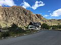
The park’s visitor center in the town of El Chaltén.
While the southern half of the park focuses on glaciers, the northern half is entirely dedicated to mountain trekking and alpinism. The hub for this is the small, wind-battered town of El Chaltén.
The Visitor Center here is the starting point for almost all major hikes. Rangers provide crucial information on trail conditions, weather warnings (which are vital for survival here), and enforce the strict rules regarding camping and waste management in the backcountry.
 5. The Trail Network

A typical trail near El Chaltén, moving from the dry Patagonian steppe toward the Andean peaks.
The park boasts hundreds of kilometers of well-maintained trekking trails. Near El Chaltén, these trails transition dramatically from the flat, dry, windy Patagonian steppe into dense, ancient Nothofagus (southern beech) forests as they approach the mountains.
These trails are world-renowned, drawing backpackers seeking to view the iconic granite spires of the Andes up close, requiring days of strenuous hiking and unpredictable weather.
Part II: The Perito Moreno Glacier (Chapters 6-12)
 6. The Face of the Glacier

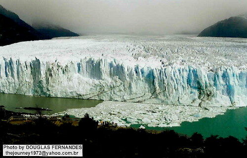
The terminus of the Perito Moreno Glacier stands up to 74 meters (240 ft) above the surface of Lago Argentino.
The Perito Moreno Glacier is the park’s undisputed main attraction. Unlike most glaciers that are hidden deep in inaccessible mountains, Perito Moreno terminates directly into Lago Argentino, allowing tourists to view its massive face from just a few hundred meters away.
The face of the glacier is a staggering wall of jagged, deep-blue ice, towering up to 74 meters (240 feet) above the water line, with a total depth of 170 meters (558 feet) extending below the surface.
 7. The Expanse of Ice

The glacier stretches 30 km (19 miles) back into the Andes mountains.
What visitors see from the boardwalks is merely the terminus. The glacier is a literal river of ice, 30 kilometers (19 miles) long, descending from the Southern Patagonian Ice Field.
The ice field acts as a massive reservoir. Heavy snowfalls in the high Andes constantly compress into solid ice, which is slowly pushed down the valley by gravity. The glacier advances at a speed of up to 2 meters per day, meaning the ice face you see is constantly fracturing, shifting, and moving.
 8. Crevasses and Seracs

The top of the glacier is a treacherous maze of deep crevasses and towering ice pinnacles known as seracs.
Because the glacier is moving over uneven bedrock, the surface of the ice is subjected to massive tension and compression forces. This causes the top layer of brittle ice to shatter.
The result is a chaotic landscape of deep, terrifying fissures (crevasses) and unstable towers of ice (seracs). Trekking on the surface of the glacier is a popular tourist activity, but it requires crampons and expert local guides to navigate safely around these hidden depths.
 9. The Calving Process

Visitors wait hours to witness the massive blocks of ice breaking off (calving) into Lago Argentino.
Because Perito Moreno is constantly advancing, the front face is continually pushed forward until it loses structural support and breaks off into the lake—a process known as calving.
This is a spectacular, deafening event. A block of ice the size of a multi-story building will suddenly fracture, falling with a thunderous crack that echoes across the valley, crashing into the water and sending massive waves toward the viewing platforms.
 10. The Birth of Icebergs

After calving, the resulting icebergs float away from the face, slowly melting in the warmer lake water.
Once a section of the glacier calves, it becomes an iceberg. These icebergs drift through the Canal de los Témpanos (Iceberg Channel) of Lago Argentino.
Because the ice has been compressed under immense pressure for hundreds of years, all the oxygen bubbles have been squeezed out. This dense ice absorbs red and yellow light, reflecting only intense, striking shades of deep blue, a signature characteristic of glacial icebergs.
 11. The Intense Blue of the Ice

The lack of air bubbles in the ancient, compressed ice is what creates the vibrant blue hue.
The vivid blue color of Perito Moreno is not a reflection of the sky, but a physical property of the ice itself. When snow falls on the high peaks, it is white and airy. Over decades, the weight of accumulating snow compresses the lower layers into dense, solid ice.
By the time that ice travels 30km to the face of the glacier, it is so incredibly dense that when white sunlight hits it, the ice absorbs the longer (red) wavelengths, and only the shorter (blue) wavelengths manage to scatter back to the viewer’s eye.
 12. Boat Safaris

Tourist boats navigate Lago Argentino to get closer views of the icebergs, maintaining a safe distance from the calving face.
To truly grasp the scale of the glacier and the resulting icebergs, many tourists take boat safaris across Lago Argentino. These boats navigate through the Canal de los Témpanos, maneuvering around massive floating chunks of ice.
However, safety regulations dictate that these boats must stay a significant distance away from the actual face of the glacier, as a sudden calving event can generate localized tsunamis capable of swamping a vessel.
Part III: Lago Argentino and the Steppe (Chapters 13-17)
 13. Lago Argentino

The largest lake in Argentina, fed entirely by glacial meltwater.
Lago Argentino is the largest freshwater lake entirely within Argentina. It is not a standard, clear lake; its waters are a distinct, milky turquoise color. This is due to “glacial flour.”
As the massive glaciers slowly grind down the mountains, they pulverize the bedrock into a microscopic, powdery dust. This fine sediment remains suspended in the meltwater, turning the lake cloudy and reflecting blue-green sunlight.
 14. The Transition Zone

The steep, rocky shores of Lago Argentino transition rapidly into dense forest before hitting the ice.
The environment directly surrounding the lake is a stark transition zone. The heavy glaciation of the past carved out deep, U-shaped valleys with steep, rocky shores.
Right up against the edge of the ice, dense, wind-battered forests of southern beech (Nothofagus) manage to cling to the thin topsoil, creating a sharp boundary between the lush green of the trees and the sterile white and blue of the glaciers.
 15. The Patagonian Wind

Moving away from the mountains, the landscape flattens into the windy, arid Patagonian steppe.
The defining feature of the entire park, extending out into the steppe, is the relentless Patagonian wind. Coming off the Pacific Ocean, the air is forced over the Andes, dropping all its moisture as snow on the ice fields.
The air then races down the eastern slopes across Lago Argentino at hurricane-force speeds. This constant, fierce wind shapes the vegetation, creating “flag trees” that grow permanently bent over, and makes trekking a grueling physical challenge.
 16. Moraines and Glacial Retreat

The rocky beaches and U-shaped valleys are evidence of massive historical glaciation that has since retreated.
While Perito Moreno is famous for advancing, many other glaciers in the park, such as the massive Upsala Glacier, are retreating rapidly due to global warming.
As they retreat, they leave behind massive piles of pulverized rock and debris known as moraines. These moraines scar the landscape, providing stark geological evidence of where the ice used to reach centuries ago, before the industrial era accelerated global melting.
 17. The Melting Giants

Small chunks of ice floating in the relatively warmer waters of the lake, slowly returning to liquid form.
The lifecycle of the glacier ends in the lake. Massive icebergs eventually break down into smaller “bergy bits” and “growlers,” slowly melting and raising the water level of Lago Argentino.
This meltwater eventually feeds into the Santa Cruz River, flowing entirely across the desolate Patagonian steppe before finally emptying into the Atlantic Ocean, completing a hydrological cycle that began as snow high in the Andes.
Part IV: The Northern Sector – El Chaltén (Chapters 18-22)
 18. The Spires of Fitz Roy

The iconic skyline of the northern sector of the park, a mecca for climbers worldwide.
Moving to the northern sector of the park, the glaciers take a backseat to the mountains. The undisputed icon of this region is Monte Fitz Roy (also known as Cerro Chaltén).
Rising 3,405 meters (11,171 ft) above sea level, it is not exceptionally high by Andean standards. However, it is an imposing, sheer granite obelisk. Its near-vertical faces and the notoriously terrible weather make it one of the most technically difficult and dangerous mountains to climb in the world.


The view of the Fitz Roy massif from near Laguna de los Tres, the culmination of the park’s most famous trek.
For non-climbers, the ultimate goal in the northern sector is the strenuous day hike to Laguna de los Tres. This glacial lake sits directly at the base of the Fitz Roy massif.
The trail requires a steep, final ascent up a moraine. Upon reaching the top, hikers are rewarded with a pristine, often frozen, turquoise lake framed perfectly by the towering granite spires of Fitz Roy and its neighboring peaks, provided the infamous Patagonian clouds haven’t obscured the view.
 20. Lago Viedma Panorama

A panorama looking back toward the massive Lago Viedma from the trails near El Chaltén.
While trekking through the Fitz Roy sector, hikers are frequently treated to expansive panoramas of Lago Viedma to the south. This massive lake is fed by the Viedma Glacier, another colossal tongue of ice descending from the Southern Patagonian Ice Field.
The scale of the landscape is difficult to comprehend; the lake stretches out into the arid steppe, providing a stark contrast between the glacial water and the dry, dusty plains.
 21. The Meltwater Streams

Countless small streams cascade down the mountainsides, carrying pristine meltwater into the lakes.
The entire park is a massive hydrological engine. During the short Patagonian summer, snowmelt and glacial runoff create a network of pristine, freezing streams and small rivers that cut through the valleys.
These streams are the lifeblood of the Nothofagus forests, providing the necessary moisture for the flora to survive the fierce, drying winds. Hikers often drink directly from these streams, as the water is filtered by the ancient rock and ice.
 22. The Subpolar Forest

Dense stands of southern beech trees dominate the lower elevations, changing colors brilliantly in autumn.
Before breaking out above the treeline into rock and ice, trekkers must navigate the subpolar Magellanic forests. Dominated by the Lenga and Ñire (types of southern beech), these forests are thick and heavily draped in Old Man’s Beard lichen (Usnea), indicating incredibly pure air.
These forests provide shelter for the park’s elusive fauna, including the Andean condor, the puma, and the highly endangered South American deer known as the Huemul.
Part V: Experiencing the Park (Chapters 23-25)
 23. The Alpenglow

Hikers wake up well before dawn to catch the first light of the sun turning the granite spires bright red.
One of the most sought-after experiences in the Fitz Roy sector is witnessing the alpenglow. Because the mountains face east, they catch the very first rays of the rising sun.
For a brief window of a few minutes, the grey granite spires are illuminated in brilliant shades of fiery red and orange. Dedicated photographers and hikers routinely brave freezing, pre-dawn temperatures to secure a viewing spot at Laguna de los Tres for this specific moment.
 24. Cerro Torre: The Impossible Peak

The skyline is dominated by impossible spires, including Cerro Torre, known as one of the hardest climbs on Earth.
Adjacent to Fitz Roy is Cerro Torre. If Fitz Roy is massive, Cerro Torre is an architectural impossibility. It is a sheer, needle-like spire of granite standing 3,128 meters high, topped with a treacherous mushroom of rime ice formed by the constant hurricane-force winds.
For decades, it was considered entirely unclimbable, and its first undisputed ascent did not occur until 1974. Today, it remains the ultimate test for elite alpinists worldwide.
 25. Summary FAQ: Los Glaciares

The park preserves a fragile ecosystem that is highly susceptible to global climate shifts.
Why is the Perito Moreno Glacier famous?
It is famous because it is highly accessible, and unlike most glaciers worldwide, it is currently advancing and in a state of equilibrium, rather than retreating due to climate change.
What is the “Rupture”?
Occasionally, the Perito Moreno Glacier advances entirely across Lago Argentino, damming the Brazo Rico section. As water pressure builds up behind the ice dam, it eventually causes the ice to shatter and collapse in a spectacular, massive natural event.
Is it dangerous to visit?
The southern glacier sector is highly developed with safe boardwalks. However, the northern sector around El Chaltén involves backcountry trekking in an environment notorious for sudden, violent storms and freezing temperatures, requiring proper gear and preparation.
Explore our trusted network of partner websites covering directories, encyclopedias, marketplaces, education, and finance.
- This digital encyclopedia is created solely as an educational reference material detailing the geography and tourism of Los Glaciares National Park.
- All included image multimedia content is distributed from the free open-license directory (GNU/Creative Commons Attribution) belonging to the worldwide Wikimedia Commons database and contributing landscape photographers.
- Geographical statistics and park regulations discussed are based on scientific consensus and reports from the Administración de Parques Nacionales of Argentina.
About the Drafting Team: Atechsur.org Geography Experts
The geographical editorial board of Atechsur.org proactively provides accurate, in-depth reports with a dedication to engaging, humanistic language to promote a future of improved global conservation and environmental appreciation.
© 2026 – Atechsur.org – Complete Los Glaciares Encyclopedia (Chapters 1 – 25)
Patagonia • UNESCO World Heritage Site • Updated: April 1, 2026